| [ Login ]/[ Register ] |
 Search ::
  My Data Basket ::
  Favorite/My Favorite :: Recent Changes :: :: Login Save in Data Basket ]
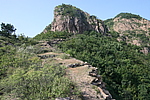
| Caption:蔓枝草长城9段 Photo Time:2007-09-19 09:51:57 Photo Contributor:辽宁省文物局 [Open in New Window] |
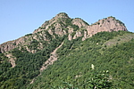
| Caption:蔓枝草长城9段 Photo Time:2007-09-19 09:24:22 Photo Contributor:辽宁省文物局 [Open in New Window] |
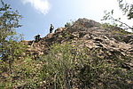
| Caption:蔓枝草长城9段 Photo Time:2007-09-19 12:01:23 Photo Contributor:辽宁省文物局 [Open in New Window] |
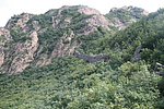
| Caption:蔓枝草长城9段 Photo Time:2007-09-19 12:14:23 Photo Contributor:辽宁省文物局 [Open in New Window] |