Official Name:
ь\МЁЧУ·й»рМЁTaiZiFengHuoTaiOur Name:
/
Other Name:
/
Period:Гч / Ming Dynasty 1368~1644
Location: МъБлКР,ІэНјПШ,ББЦРЗЕХтєЪМЁГнґе7Ч鶫±±1З§ГЧґ¦ / TieLingShi,ChangTuXian,LiangZhongQiaoZhenHeiTaiMiaoCun7ZuDongBei1QianMiChu
ЎЎ[
Looking Local List]
Details:і¤іЗАа±рЈєµҐМеЅЁЦю
ѕОіёЯ¶ИЈє¶«ѕЈє123Ўг 55Ўд ±±ОіЈє42Ўг 43Ўд єЈ°ОЈє153
ЅЁЦюРОКЅЈєПЦґжХыМеОЄВшКЧЧґЈ¬ЖЅГжОЄФІРОЈ¬ЖКГжіКМЭРОЎЈКµјКЗйїцІ»ЗеЎЈ
ІДБПЈєНБЎўЧ©ЎЈ
ёЅЅьТЕґжЈє·й»рМЁ¶«±±ѕаАлёЯФґе±±МЁЧУ·й»рМЁ1.7З§ГЧЈ¬¶«ДПѕаАлУАДю±¤3.8З§ГЧЎЈ
Type:·й»рМЁ Beacon Tower
Protection Level:ОЮЎЎ
Content:
Memo:
Other Records:
Distribution:
visit location in Tianditu Map[recommend] Distribution:
visit location in Tencent QQ Map Distribution:
visit location in Google MapDistribution:
visit location in Baidu MapNational ID:211224353201170058
Action:[
 Save in Data Basket
 ]
Picture:
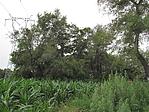
Click the thumbnail to view the Big Pic. Click the Big Pic to Hide the Big Pic![Caption:ьМЁЧУ·й»рМЁ
loading images --Please wait...]()
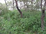
![Caption:ьМЁЧУ·й»рМЁ
loading images --Please wait...]()
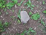
![Caption:ьМЁЧУ·й»рМЁ
loading images --Please wait...]() Photo Links
Photo Links:
ЎЎ Search ::
  Favorite/My Favorite :: Recent Changes :: :: Login